Ghogha night lights from space
Night Light of Ghogha (Gujarat) from space (India) Src. Average luminocity for 10x10km area is 5.0492% and for 50x50km: 12.5233%.
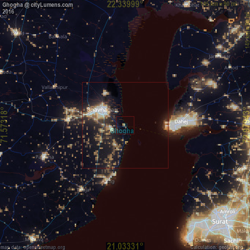
Analysis of Ghogha night lights 2016
Square area 10x10 km:
 0%
0%90-99
0%80-89
0.57%70-79
0.19%60-69
1.14%50-59
0.38%40-49
0.76%30-39
1.52%20-29
0.76%10-19
3.98%0-9
90.72%Square area 50x50 km:
0.71%90-99
1.88%80-89
1.25%70-79
1.36%60-69
1.76%50-59
2.27%40-49
2.2%30-39
2.79%20-29
5.28%10-19
11.15%0-9
69.36%Clear (daylight) street map image can be seen on geolist.org.
Map coordinates:
22° 20' 24" North, 71° 34' 23.4" East
21° 41' 17.3" North, 72° 16' 34.7" East
21° 1' 59.9" North, 72° 58' 45.9" East
Some cities around Ghogha sort by population:
• Bhavnagar
15.2 km =9.4 mi,  303°
303°
• Pālitāna
50.2 km =31.2 mi,  248°
248°
• Sihor
32.6 km =20.3 mi,  274°
274°
• Talāja
44.9 km =27.9 mi,  213°
213°
• Valabhīpur
46.7 km =29 mi, 298°
• Hansot
56.1 km =34.9 mi,  101°
101°
• Umrāla
51.8 km =32.2 mi,  289°
289°
• Vartej
22.5 km =14 mi,  284°
284°
1271285 (p: 11,361)
Sources (retrieved 2019-11-25):
» Earth at Night: Flat Maps 2012, 2016