Ghansor night lights from space
Night Light of Ghansor (Madhya Pradesh) from space (India) Src. Average luminocity for 10x10km area is 4.5933% and for 50x50km: 1.582%.
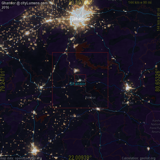
Analysis of Ghansor night lights 2016
Square area 10x10 km:
 0.6%
0.6%90-99
0.2%80-89
0%70-79
0.79%60-69
0.79%50-59
0%40-49
1.59%30-39
0.79%20-29
1.79%10-19
0.2%0-9
93.25%Square area 50x50 km:
0.1%90-99
0.13%80-89
0.04%70-79
0.07%60-69
0.15%50-59
0.33%40-49
0.53%30-39
0.51%20-29
0.7%10-19
0.44%0-9
96.99%Clear (daylight) street map image can be seen on geolist.org.
Map coordinates:
23° 18' 25.4" North, 79° 14' 49.2" East
22° 39' 35.1" North, 79° 57' 0.5" East
22° 0' 33.8" North, 80° 39' 11.7" East
Some cities around Ghansor sort by population:
• Jabalpur
56.4 km =35 mi,  359°
359°
• Mandlā
43.7 km =27.2 mi,  98°
98°
• Nainpur
30.1 km =18.7 mi,  147°
147°
• Bargi
37.7 km =23.4 mi,  348°
348°
• Lakhnādon
36.4 km =22.6 mi,  259°
259°
• Khamaria
63.3 km =39.3 mi, 353°
• Shāhpura
60.6 km =37.7 mi,  331°
331°
• Barela
49.7 km =30.9 mi,  11°
11°
1271374 (p: 6,597)
Sources (retrieved 2019-11-25):
» Earth at Night: Flat Maps 2012, 2016