Barela night lights from space
Night Light of Barela (Madhya Pradesh) from space (India) Src. Average luminocity for 10x10km area is 25.2557% and for 50x50km: 21.5986%.
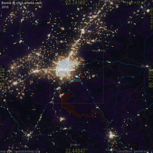
Analysis of Barela night lights 2016
Square area 10x10 km:
 0.95%
0.95%90-99
2.27%80-89
0.76%70-79
3.22%60-69
2.46%50-59
3.79%40-49
8.33%30-39
10.8%20-29
12.31%10-19
21.78%0-9
33.33%Square area 50x50 km:
5.82%90-99
4.14%80-89
1.62%70-79
1.86%60-69
2.5%50-59
3.02%40-49
3.5%30-39
3.66%20-29
4.91%10-19
6.39%0-9
62.58%Clear (daylight) street map image can be seen on geolist.org.
Map coordinates:
23° 44' 31.1" North, 79° 20' 51.8" East
23° 5' 48.4" North, 80° 3' 3" East
22° 26' 54.5" North, 80° 45' 14.3" East
Some cities around Barela sort by population:
• Jabalpur
12.9 km =8 mi,  307°
307°
• Sihorā
43.7 km =27.2 mi,  7°
7°
• Panāgar
21.7 km =13.5 mi,  344°
344°
• Kaimori
44.8 km =27.8 mi,  315°
315°
• Bargi
21.4 km =13.3 mi,  236°
236°
• Khamaria
22.6 km =14 mi, 309°
• Pātan
42.5 km =26.4 mi,  299°
299°
• Shāhpura
39.8 km =24.7 mi,  276°
276°
1277008 (p: 11,648)
Sources (retrieved 2019-11-25):
» Earth at Night: Flat Maps 2012, 2016