Garui night lights from space
Night Light of Garui (West Bengal) from space (India) Src. Average luminocity for 10x10km area is 99.9564% and for 50x50km: 79.5849%.
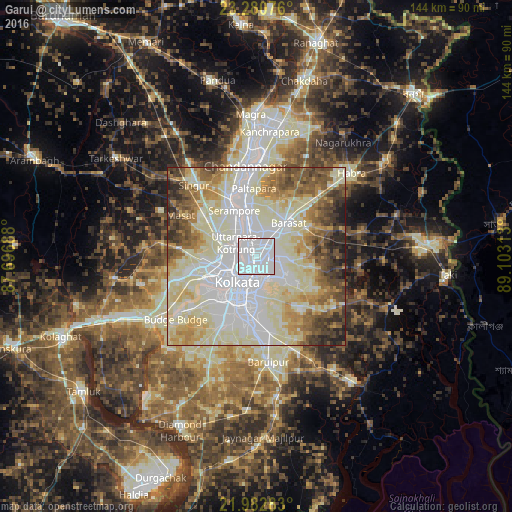
Analysis of Garui night lights 2016
Square area 10x10 km:
 95.83%
90-99
4.17%80-89
0%70-79
0%60-69
0%50-59
0%40-49
0%30-39
0%20-29
0%10-19
0%0-9
0%Square area 50x50 km:
24.35%90-99
27.5%80-89
12.12%70-79
6.74%60-69
7.25%50-59
7.17%40-49
6.12%30-39
4.37%20-29
3.3%10-19
1.08%0-9
0%Clear (daylight) street map image can be seen on geolist.org.
Map coordinates:
23° 16' 50.7" North, 87° 41' 48.8" East
22° 37' 60" North, 88° 24' 0" East
21° 58' 58.2" North, 89° 6' 11.3" East
Some cities around Garui sort by population:
• Pānihāti
6.9 km =4.3 mi,  337°
337°
• Kāmārhāti
4.9 km =3 mi,  328°
328°
• Bāli
6.3 km =3.9 mi,  285°
285°
• Baranagar
2.5 km =1.6 mi, 290°
• Madhyamgram
7.8 km =4.8 mi,  37°
37°
• Dam Dam
2.3 km =1.4 mi,  89°
89°
• Chakapara
5.3 km =3.3 mi,  268°
268°
• Sodpur
7.9 km =4.9 mi,  353°
353°
1271495 (p: 16,499)
Sources (retrieved 2019-11-25):
» Earth at Night: Flat Maps 2012, 2016