Gandai night lights from space
Night Light of Gandai (Chhattisgarh) from space (India) Src. Average luminocity for 10x10km area is 13.9867% and for 50x50km: 7.3064%.
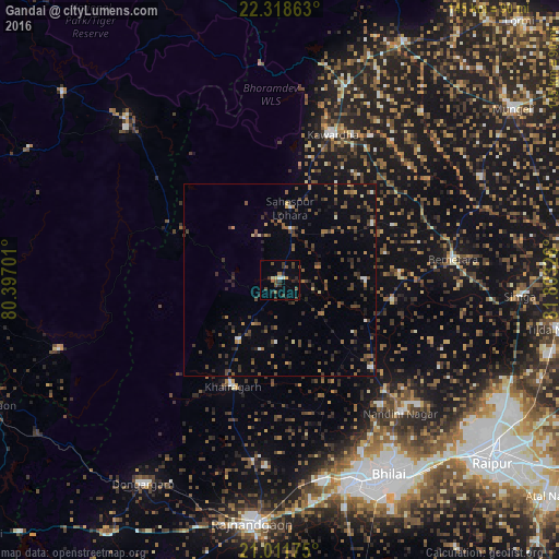
Analysis of Gandai night lights 2016
Square area 10x10 km:
 0.38%
0.38%90-99
1.89%80-89
1.14%70-79
0.38%60-69
0.76%50-59
2.84%40-49
4.55%30-39
5.68%20-29
4.73%10-19
1.89%0-9
75.76%Square area 50x50 km:
0.26%90-99
0.43%80-89
0.27%70-79
0.49%60-69
0.97%50-59
1.64%40-49
2.19%30-39
2.23%20-29
2.13%10-19
3.12%0-9
86.28%Clear (daylight) street map image can be seen on geolist.org.
Map coordinates:
22° 19' 7.1" North, 80° 23' 49.2" East
21° 40' 0" North, 81° 6' 0.5" East
21° 0' 42.3" North, 81° 48' 11.7" East
Some cities around Gandai sort by population:
• Bhilai
61.2 km =38 mi,  146°
146°
• Durg
55.9 km =34.7 mi,  160°
160°
• Kumhāri
61.9 km =38.5 mi,  135°
135°
• Kawardha
40.4 km =25.1 mi,  19°
19°
• Bemetāra
45.2 km =28.1 mi,  83°
83°
• Khairāgarh
30.3 km =18.8 mi,  204°
204°
• Pāndātarai
62.5 km =38.8 mi, 22°
• Chhuīkhadān
19.1 km =11.9 mi,  213°
213°
1271734 (p: 12,475)
Sources (retrieved 2019-11-25):
» Earth at Night: Flat Maps 2012, 2016