Elumalai night lights from space
Night Light of Elumalai (Tamil Nadu) from space (India) Src. Average luminocity for 10x10km area is 1.9827% and for 50x50km: 2.4173%.
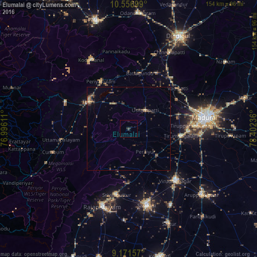
Analysis of Elumalai night lights 2016
Square area 10x10 km:
 0%
0%90-99
0%80-89
0%70-79
0%60-69
0%50-59
0%40-49
1.3%30-39
0.87%20-29
1.52%10-19
2.38%0-9
93.94%Square area 50x50 km:
0%90-99
0%80-89
0.23%70-79
0.23%60-69
0.18%50-59
0.63%40-49
0.96%30-39
0.63%20-29
1.18%10-19
1.23%0-9
94.73%Clear (daylight) street map image can be seen on geolist.org.
Map coordinates:
10° 33' 25.2" North, 76° 59' 46" East
9° 51' 54" North, 77° 41' 57.2" East
9° 10' 17.7" North, 78° 24' 8.5" East
Some cities around Elumalai sort by population:
• Teni
29.2 km =18.1 mi,  303°
303°
• Periyakulam
33.3 km =20.7 mi,  329°
329°
• Usilampatti
15 km =9.3 mi,  39°
39°
• Āndippatti
17.1 km =10.6 mi, 329°
• Vattalkundu
33.5 km =20.8 mi,  11°
11°
• Devadānappatti
31.9 km =19.8 mi,  349°
349°
• Kallupatti
24.7 km =15.3 mi,  131°
131°
• Peraiyur
17.4 km =10.8 mi,  145°
145°
1272053 (p: 14,456)
Sources (retrieved 2019-11-25):
» Earth at Night: Flat Maps 2012, 2016