Dhanaula night lights from space
Night Light of Dhanaula (Punjab) from space (India) Src. Average luminocity for 10x10km area is 20.1172% and for 50x50km: 15.6146%.
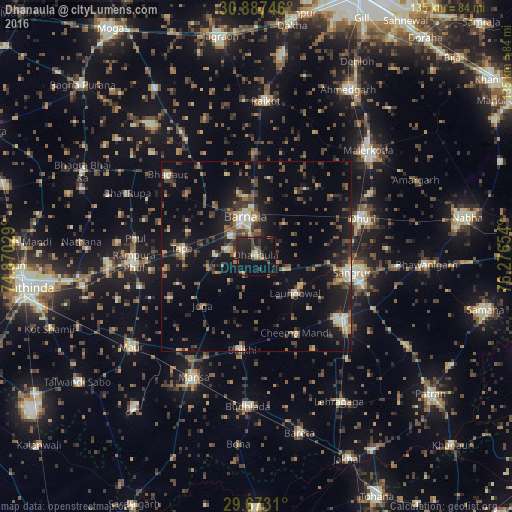
Analysis of Dhanaula night lights 2016
Square area 10x10 km:
 0.37%
0.37%90-99
0.37%80-89
1.83%70-79
2.01%60-69
1.83%50-59
3.11%40-49
5.13%30-39
4.03%20-29
12.09%10-19
31.32%0-9
37.91%Square area 50x50 km:
0.58%90-99
1.49%80-89
1.82%70-79
1.28%60-69
1.84%50-59
2.98%40-49
3.63%30-39
3.75%20-29
4.64%10-19
13.6%0-9
64.38%Clear (daylight) street map image can be seen on geolist.org.
Map coordinates:
30° 53' 14.9" North, 74° 52' 13" East
30° 16' 55.8" North, 75° 34' 24.3" East
29° 40' 23.2" North, 76° 16' 35.5" East
Some cities around Dhanaula sort by population:
• Barnāla
10.5 km =6.5 mi,  346°
346°
• Sangrūr
26.4 km =16.4 mi,  98°
98°
• Dhūri
29.8 km =18.5 mi,  71°
71°
• Sunām
27.6 km =17.1 mi,  128°
128°
• Rāmpura
32 km =19.9 mi,  264°
264°
• Laungowāl
14.2 km =8.8 mi, 133°
• Bhadaur
31.8 km =19.8 mi,  312°
312°
• Bhīkhi
25.1 km =15.6 mi,  188°
188°
1272985 (p: 19,281)
Sources (retrieved 2019-11-25):
» Earth at Night: Flat Maps 2012, 2016