Chāmpāhāti night lights from space
Night Light of Chāmpāhāti (West Bengal) from space (India) Src. Average luminocity for 10x10km area is 81.8617% and for 50x50km: 59.4738%.
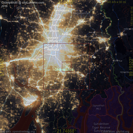
Analysis of Chāmpāhāti night lights 2016
Square area 10x10 km:
 4.73%
4.73%90-99
33.52%80-89
28.79%70-79
8.9%60-69
14.02%50-59
5.49%40-49
3.03%30-39
1.52%20-29
0%10-19
0%0-9
0%Square area 50x50 km:
15.2%90-99
13.73%80-89
9.37%70-79
6.07%60-69
8.1%50-59
7.54%40-49
7.49%30-39
7.59%20-29
8.25%10-19
7.65%0-9
9.01%Clear (daylight) street map image can be seen on geolist.org.
Map coordinates:
23° 2' 55.7" North, 87° 47' 20.3" East
22° 24' 0.9" North, 88° 29' 31.5" East
21° 44' 55.2" North, 89° 11' 42.8" East
Some cities around Chāmpāhāti sort by population:
• Kolkata
22.4 km =13.9 mi,  323°
323°
• Bārāsat
19.9 km =12.4 mi,  192°
192°
• Bāruipur
7.6 km =4.7 mi,  225°
225°
• Canning
19.9 km =12.4 mi,  118°
118°
• Nabagrām
12.6 km =7.8 mi,  171°
171°
• Amtala
22.2 km =13.8 mi,  261°
261°
• Serpur
20.8 km =12.9 mi,  245°
245°
• Raypur
2.1 km =1.3 mi,  56°
56°
1274834 (p: 8,923)
Sources (retrieved 2019-11-25):
» Earth at Night: Flat Maps 2012, 2016