Amtala night lights from space
Night Light of Amtala (West Bengal) from space (India) Src. Average luminocity for 10x10km area is 82.4261% and for 50x50km: 71.1903%.
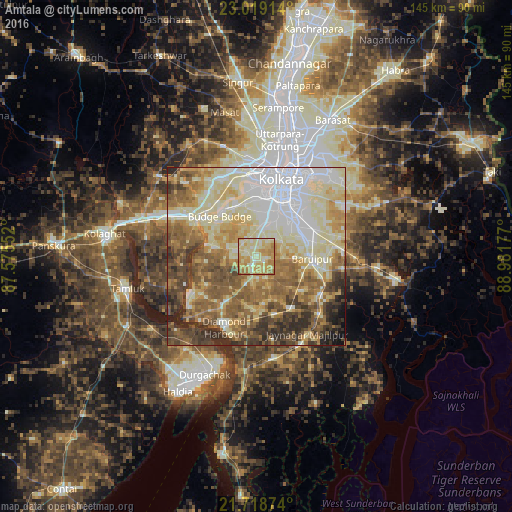
Analysis of Amtala night lights 2016
Square area 10x10 km:
 2.84%
2.84%90-99
27.08%80-89
30.68%70-79
24.05%60-69
14.96%50-59
0.38%40-49
0%30-39
0%20-29
0%10-19
0%0-9
0%Square area 50x50 km:
13.92%90-99
19.25%80-89
12.84%70-79
8.96%60-69
11.45%50-59
12.37%40-49
8.13%30-39
6.51%20-29
5.15%10-19
1.25%0-9
0.16%Clear (daylight) street map image can be seen on geolist.org.
Map coordinates:
23° 1' 8.9" North, 87° 34' 31.9" East
22° 22' 13.7" North, 88° 16' 43.1" East
21° 43' 7.5" North, 88° 58' 54.4" East
Some cities around Amtala sort by population:
• Nangi
16.7 km =10.4 mi,  336°
336°
• Baj Baj
15.6 km =9.7 mi,  318°
318°
• Bāruipur
16.6 km =10.3 mi,  96°
96°
• Pujali
17.7 km =11 mi,  309°
309°
• Jāfarpur
7.6 km =4.7 mi,  220°
220°
• Bāwāli
10.7 km =6.6 mi,  304°
304°
• Serpur
6 km =3.7 mi,  150°
150°
• Santoshpur
16.7 km =10.4 mi,  356°
356°
1348870 (p: 8,266)
Sources (retrieved 2019-11-25):
» Earth at Night: Flat Maps 2012, 2016