Raypur night lights from space
Night Light of Raypur (West Bengal) from space (India) Src. Average luminocity for 10x10km area is 73.5455% and for 50x50km: 57.4864%.
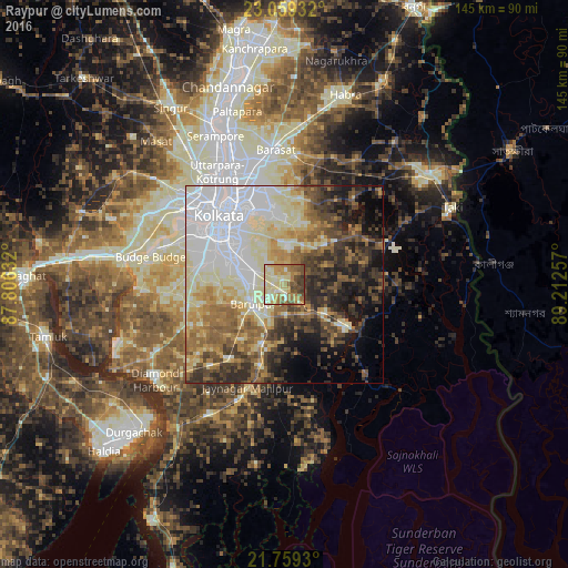
Analysis of Raypur night lights 2016
Square area 10x10 km:
 2.65%
2.65%90-99
21.78%80-89
22.16%70-79
12.31%60-69
15.91%50-59
9.28%40-49
10.23%30-39
5.49%20-29
0.19%10-19
0%0-9
0%Square area 50x50 km:
15.21%90-99
12.51%80-89
8.56%70-79
5.9%60-69
7.78%50-59
7.25%40-49
7.55%30-39
7.83%20-29
8.48%10-19
8.68%0-9
10.23%Clear (daylight) street map image can be seen on geolist.org.
Map coordinates:
23° 3' 33.6" North, 87° 48' 22.8" East
22° 24' 39" North, 88° 30' 34" East
21° 45' 33.5" North, 89° 12' 45.3" East
Some cities around Raypur sort by population:
• Kolkata
22.6 km =14 mi,  318°
318°
• Bārāsat
21.5 km =13.4 mi,  196°
196°
• Bāruipur
9.7 km =6 mi,  228°
228°
• Canning
19 km =11.8 mi,  124°
124°
• Nabagrām
13.7 km =8.5 mi,  180°
180°
• Chāmpāhāti
2.1 km =1.3 mi,  236°
236°
• Bara Bazar
23.8 km =14.8 mi, 316°
• Serpur
22.9 km =14.2 mi, 244°
1349355 (p: 6,907)
Sources (retrieved 2019-11-25):
» Earth at Night: Flat Maps 2012, 2016