Bijāwar night lights from space
Night Light of Bijāwar (Madhya Pradesh) from space (India) Src. Average luminocity for 10x10km area is 12.8254% and for 50x50km: 5.6479%.
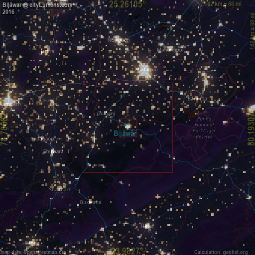
Analysis of Bijāwar night lights 2016
Square area 10x10 km:
 1.19%
1.19%90-99
1.98%80-89
0.6%70-79
1.19%60-69
1.39%50-59
1.59%40-49
3.17%30-39
2.38%20-29
3.57%10-19
2.38%0-9
80.56%Square area 50x50 km:
0.21%90-99
0.44%80-89
0.32%70-79
0.55%60-69
0.86%50-59
1.2%40-49
1.51%30-39
1.12%20-29
1.36%10-19
1.84%0-9
90.6%Clear (daylight) street map image can be seen on geolist.org.
Map coordinates:
25° 15' 39.8" North, 78° 47' 12.6" East
24° 37' 24.6" North, 79° 29' 23.8" East
23° 58' 57.7" North, 80° 11' 35.1" East
Some cities around Bijāwar sort by population:
• Chhatarpur
34.2 km =21.3 mi,  16°
16°
• Khajuraho Group of Monuments
51.3 km =31.9 mi,  60°
60°
• Palera
51.4 km =31.9 mi,  329°
329°
• Shāhgarh
51 km =31.7 mi,  227°
227°
• Khargāpur
41.4 km =25.7 mi,  302°
302°
• Rājnagar
51.8 km =32.2 mi, 55°
• Bakshwāho
46.3 km =28.8 mi,  206°
206°
• Baldeogarh
45.2 km =28.1 mi,  289°
289°
1275694 (p: 19,468)
Sources (retrieved 2019-11-25):
» Earth at Night: Flat Maps 2012, 2016