Bariārpur night lights from space
Night Light of Bariārpur (Bihar) from space (India) Src. Average luminocity for 10x10km area is 37.256% and for 50x50km: 20.1383%.
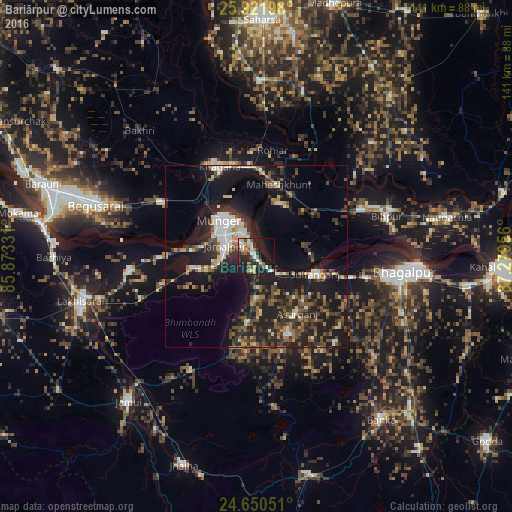
Analysis of Bariārpur night lights 2016
Square area 10x10 km:
 4.17%
4.17%90-99
8.53%80-89
5.56%70-79
2.78%60-69
3.17%50-59
6.35%40-49
5.16%30-39
5.36%20-29
13.29%10-19
34.13%0-9
11.51%Square area 50x50 km:
2.28%90-99
2.71%80-89
1.72%70-79
1.49%60-69
2.25%50-59
3.01%40-49
4.07%30-39
4.87%20-29
8.59%10-19
19.49%0-9
49.52%Clear (daylight) street map image can be seen on geolist.org.
Map coordinates:
25° 55' 19.1" North, 85° 52' 23.9" East
25° 17' 16.5" North, 86° 34' 35.1" East
24° 39' 1.8" North, 87° 16' 46.4" East
Some cities around Bariārpur sort by population:
• Bhāgalpur
40.1 km =24.9 mi,  96°
96°
• Monghyr
14.1 km =8.8 mi,  313°
313°
• Begusarai
46.8 km =29.1 mi,  288°
288°
• Jamālpur
9.2 km =5.7 mi, 287°
• Khagaria
26.2 km =16.3 mi,  335°
335°
• Kharagpur
18.3 km =11.4 mi,  186°
186°
• Amarpur
42.9 km =26.7 mi,  130°
130°
• Asarganj
18.9 km =11.7 mi,  144°
144°
1276945 (p: 14,595)
Sources (retrieved 2019-11-25):
» Earth at Night: Flat Maps 2012, 2016