Bāli night lights from space
Night Light of Bāli (Rajasthan) from space (India) Src. Average luminocity for 10x10km area is 9.1369% and for 50x50km: 3.5639%.
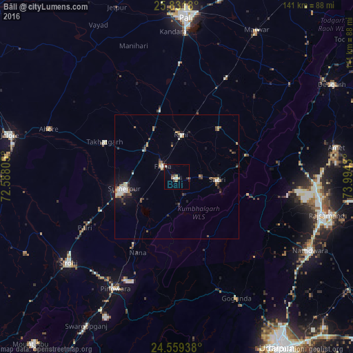
Analysis of Bāli night lights 2016
Square area 10x10 km:
 0%
0%90-99
2.78%80-89
0.4%70-79
0.99%60-69
1.59%50-59
0.79%40-49
2.18%30-39
1.79%20-29
1.19%10-19
0.6%0-9
87.7%Square area 50x50 km:
0.18%90-99
0.87%80-89
0.25%70-79
0.32%60-69
0.57%50-59
0.6%40-49
0.58%30-39
0.46%20-29
0.67%10-19
1.81%0-9
93.68%Clear (daylight) street map image can be seen on geolist.org.
Map coordinates:
25° 49' 54.5" North, 72° 35' 17" East
25° 11' 50.1" North, 73° 17' 28.2" East
24° 33' 33.8" North, 73° 59' 39.5" East
Some cities around Bāli sort by population:
• Rājsamand
60.9 km =37.8 mi,  103°
103°
• Nāthdwāra
60.9 km =37.8 mi,  118°
118°
• Sirohi
56.3 km =35 mi,  232°
232°
• Sheoganj
23.4 km =14.5 mi,  253°
253°
• Sādri
16.3 km =10.1 mi,  94°
94°
• Pindwāra
50.4 km =31.3 mi,  208°
208°
• Takhatgarh
32 km =19.9 mi,  295°
295°
• Rāni
17.1 km =10.6 mi,  5°
5°
1277590 (p: 19,259)
Sources (retrieved 2019-11-25):
» Earth at Night: Flat Maps 2012, 2016