Bābra night lights from space
Night Light of Bābra (Gujarat) from space (India) Src. Average luminocity for 10x10km area is 10.9246% and for 50x50km: 3.718%.
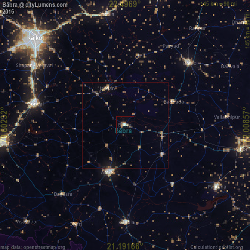
Analysis of Bābra night lights 2016
Square area 10x10 km:
100  0%
0%
90-99 3.17%
80-89 0.79%
70-79 0%
60-69 2.78%
50-59 2.38%
40-49 1.98%
30-39 0.79%
20-29 1.59%
10-19 2.38%
0-9 84.13%
0%90-99
3.17%80-89
0.79%70-79
0%60-69
2.78%50-59
2.38%40-49
1.98%30-39
0.79%20-29
1.59%10-19
2.38%0-9
84.13%Square area 50x50 km:
100 0%
90-99 0.32%
80-89 0.19%
70-79 0.44%
60-69 0.68%
50-59 0.89%
40-49 0.95%
30-39 1.06%
20-29 0.96%
10-19 1.47%
0-9 93.06%
0%90-99
0.32%80-89
0.19%70-79
0.44%60-69
0.68%50-59
0.89%40-49
0.95%30-39
1.06%20-29
0.96%10-19
1.47%0-9
93.06%Clear (daylight) street map image can be seen on geolist.org.
Map coordinates:
22° 29' 48.8" North, 70° 36' 8.4" East
21° 50' 44.8" North, 71° 18' 19.6" East
21° 11' 30" North, 72° 0' 30.9" East
Some cities around Bābra sort by population:
• Amreli
29 km =18 mi,  199°
199°
• Jasdan
23.5 km =14.6 mi,  334°
334°
• Gariadhar
44.2 km =27.5 mi,  140°
140°
• Gadhada
31.3 km =19.4 mi,  63°
63°
• Lāthi
16.1 km =10 mi,  147°
147°
• Dāmnagar
27.8 km =17.3 mi,  127°
127°
• Vinchia
41.2 km =25.6 mi,  10°
10°
• Dhola
48.4 km =30.1 mi,  85°
85°
1278054 (p: 18,993)
Sources (retrieved 2019-11-25):
» Earth at Night: Flat Maps 2012, 2016