Awantipur night lights from space
Night Light of Awantipur (Jammu and Kashmir) from space (India) Src. Average luminocity for 10x10km area is 15.1713% and for 50x50km: 14.2796%.
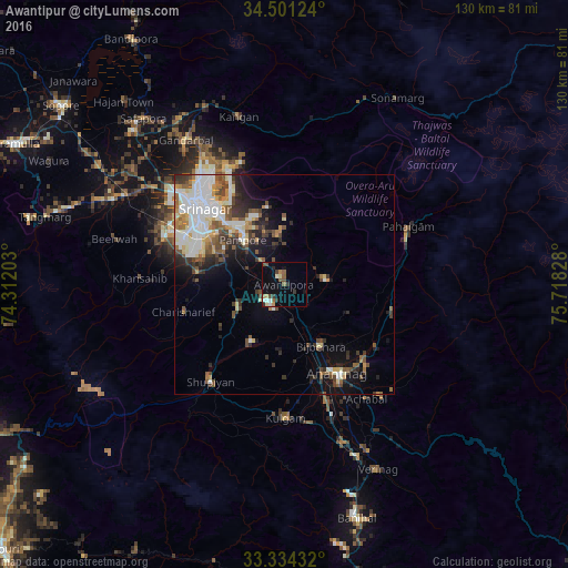
Analysis of Awantipur night lights 2016
Square area 10x10 km:
 1.75%
1.75%90-99
1.75%80-89
1.4%70-79
1.57%60-69
1.4%50-59
4.2%40-49
2.1%30-39
2.8%20-29
1.92%10-19
5.77%0-9
75.35%Square area 50x50 km:
2.96%90-99
3.19%80-89
1.38%70-79
1.26%60-69
1.25%50-59
2.2%40-49
2.28%30-39
2.27%20-29
2.76%10-19
5.3%0-9
75.15%Clear (daylight) street map image can be seen on geolist.org.
Map coordinates:
34° 30' 4.5" North, 74° 18' 43.3" East
33° 55' 11.2" North, 75° 0' 54.5" East
33° 20' 3.6" North, 75° 43' 5.8" East
Some cities around Awantipur sort by population:
• Srinagar
26.7 km =16.6 mi,  313°
313°
• Anantnag
24.6 km =15.3 mi,  148°
148°
• Bijbehara
16.4 km =10.2 mi, 148°
• Pulwama
11.8 km =7.3 mi,  244°
244°
• Shupīyan
28.1 km =17.5 mi,  216°
216°
• Trāl
9.3 km =5.8 mi,  85°
85°
• Tsrār Sharīf
23.9 km =14.9 mi,  254°
254°
• Pahlgām
30 km =18.6 mi,  69°
69°
1278103 (p: 6,807)
Sources (retrieved 2019-11-25):
» Earth at Night: Flat Maps 2012, 2016