Ahmadpur night lights from space
Night Light of Ahmadpur (West Bengal) from space (India) Src. Average luminocity for 10x10km area is 13.4901% and for 50x50km: 20.2992%.
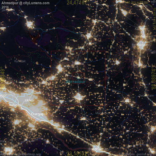
Analysis of Ahmadpur night lights 2016
Square area 10x10 km:
 0.4%
0.4%90-99
0.4%80-89
0%70-79
2.18%60-69
0.99%50-59
1.79%40-49
5.16%30-39
3.17%20-29
4.17%10-19
11.31%0-9
70.44%Square area 50x50 km:
1.29%90-99
2.36%80-89
1.24%70-79
1.46%60-69
2.39%50-59
3.65%40-49
4.73%30-39
5%20-29
9.21%10-19
22.59%0-9
46.09%Clear (daylight) street map image can be seen on geolist.org.
Map coordinates:
24° 28' 18" North, 86° 59' 0.6" East
23° 49' 48.3" North, 87° 41' 11.8" East
23° 11' 7.2" North, 88° 23' 23.1" East
Some cities around Ahmadpur sort by population:
• Kātoya
49.8 km =30.9 mi,  114°
114°
• Bolpur
18.6 km =11.6 mi,  176°
176°
• Siuri
18.3 km =11.4 mi,  298°
298°
• Kāndi
38.7 km =24 mi,  68°
68°
• Rampur Hat
39.8 km =24.7 mi,  14°
14°
• Sainthia
13.2 km =8.2 mi,  357°
357°
• Dubrājpur
31.9 km =19.8 mi,  261°
261°
• Guskhara
37.8 km =23.5 mi,  172°
172°
1279225 (p: 8,855)
Sources (retrieved 2019-11-25):
» Earth at Night: Flat Maps 2012, 2016