Jobstown night lights from space
Night Light of Jobstown (Leinster) from space (Ireland) Src. Average luminocity for 10x10km area is 55.1187% and for 50x50km: 24.2803%.
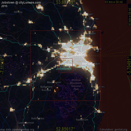
Analysis of Jobstown night lights 2016
Square area 10x10 km:
 17.05%
90-99
19.07%80-89
4.67%70-79
2.65%60-69
1.77%50-59
2.27%40-49
4.42%30-39
7.95%20-29
14.27%10-19
18.56%0-9
7.32%Square area 50x50 km:
8.26%90-99
5.48%80-89
1.73%70-79
1.82%60-69
1.76%50-59
1.75%40-49
2.34%30-39
2.75%20-29
5.15%10-19
10.64%0-9
58.31%Clear (daylight) street map image can be seen on geolist.org.
Map coordinates:
53° 41' 49.2" North, 7° 6' 40.2" West
53° 16' 43.2" North, 6° 24' 28.9" West
52° 51' 22.2" North, 5° 42' 17.7" West
Some cities around Jobstown sort by population:
• Tallaght
2.4 km =1.5 mi,  70°
70°
• Knocklyon
5.1 km =3.2 mi,  87°
87°
• Clondalkin
5.1 km =3.2 mi,  8°
8°
• Oldbawn
2.7 km =1.7 mi,  97°
97°
• Ballyboden
6.1 km =3.8 mi, 88°
• Cherry Orchard
6.7 km =4.2 mi,  17°
17°
• Templeogue
6.8 km =4.2 mi, 74°
• Firhouse
4.6 km =2.9 mi, 85°
7869995 (p: 10,825)
Sources (retrieved 2019-11-25):
» Earth at Night: Flat Maps 2012, 2016