Ballyboden night lights from space
Night Light of Ballyboden (Leinster) from space (Ireland) Src. Average luminocity for 10x10km area is 70.4457% and for 50x50km: 23.6991%.
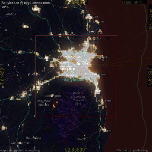
Analysis of Ballyboden night lights 2016
Square area 10x10 km:
 28.91%
90-99
26.77%80-89
3.91%70-79
1.52%60-69
1.77%50-59
0.63%40-49
3.16%30-39
8.33%20-29
15.15%10-19
9.85%0-9
0%Square area 50x50 km:
8.23%90-99
5.42%80-89
1.7%70-79
1.73%60-69
1.69%50-59
1.67%40-49
2.21%30-39
2.66%20-29
5.11%10-19
10.16%0-9
59.42%Clear (daylight) street map image can be seen on geolist.org.
Map coordinates:
53° 41' 56" North, 7° 1' 10.3" West
53° 16' 50" North, 6° 18' 59" West
52° 51' 29.1" North, 5° 36' 47.8" West
Some cities around Ballyboden sort by population:
• Tallaght
3.8 km =2.4 mi,  278°
278°
• Knocklyon
1 km =0.6 mi,  268°
268°
• Dundrum
4.1 km =2.5 mi,  74°
74°
• Oldbawn
3.4 km =2.1 mi,  260°
260°
• Ballinteer
4.2 km =2.6 mi,  99°
99°
• Terenure
3.8 km =2.4 mi,  32°
32°
• Templeogue
1.7 km =1.1 mi,  16°
16°
• Firhouse
1.5 km =0.9 mi, 274°
2966670 (p: 9,611)
Sources (retrieved 2019-11-25):
» Earth at Night: Flat Maps 2012, 2016