Clane night lights from space
Night Light of Clane (Leinster) from space (Ireland) Src. Average luminocity for 10x10km area is 9.7828% and for 50x50km: 12.7384%.
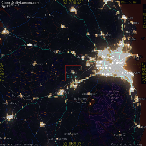
Analysis of Clane night lights 2016
Square area 10x10 km:
100  0.13%
0.13%
90-99 0.88%
80-89 0.51%
70-79 1.01%
60-69 1.14%
50-59 0.88%
40-49 2.4%
30-39 1.52%
20-29 1.01%
10-19 20.33%
0-9 70.2%
0.13%90-99
0.88%80-89
0.51%70-79
1.01%60-69
1.14%50-59
0.88%40-49
2.4%30-39
1.52%20-29
1.01%10-19
20.33%0-9
70.2%Square area 50x50 km:
100 3.06%
90-99 3%
80-89 1.13%
70-79 1.23%
60-69 1.08%
50-59 1.1%
40-49 1.38%
30-39 1.49%
20-29 2.55%
10-19 6.52%
0-9 77.46%
3.06%90-99
3%80-89
1.13%70-79
1.23%60-69
1.08%50-59
1.1%40-49
1.38%30-39
1.49%20-29
2.55%10-19
6.52%0-9
77.46%Clear (daylight) street map image can be seen on geolist.org.
Map coordinates:
53° 42' 34.6" North, 7° 23' 32.2" West
53° 17' 29" North, 6° 41' 21" West
52° 52' 8.5" North, 5° 59' 9.7" West
Some cities around Clane sort by population:
• Naas
8.5 km =5.3 mi,  170°
170°
• Celbridge
11.1 km =6.9 mi,  59°
59°
• Droichead Nua
14.1 km =8.8 mi,  210°
210°
• Leixlip
15.3 km =9.5 mi, 57°
• Maynooth
12.2 km =7.6 mi,  31°
31°
• Kilcock
12.4 km =7.7 mi,  5°
5°
• Eadestown
12.3 km =7.6 mi,  143°
143°
• Sallins
5 km =3.1 mi,  162°
162°
2965484 (p: 6,702)
Sources (retrieved 2019-11-25):
» Earth at Night: Flat Maps 2012, 2016