Legian night lights from space
Night Light of Legian (Bali) from space (Indonesia) Src. Average luminocity for 10x10km area is 72.9525% and for 50x50km: 25.4566%.
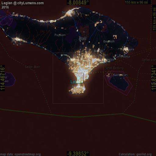
Analysis of Legian night lights 2016
Square area 10x10 km:
 22.31%
90-99
29.96%80-89
8.06%70-79
4.34%60-69
1.86%50-59
3.72%40-49
1.24%30-39
10.95%20-29
13.22%10-19
4.34%0-9
0%Square area 50x50 km:
2.69%90-99
6.41%80-89
4.43%70-79
4.97%60-69
2.83%50-59
3.44%40-49
3.37%30-39
3.26%20-29
4.96%10-19
8.02%0-9
55.63%Clear (daylight) street map image can be seen on geolist.org.
Map coordinates:
8° 0' 30.6" South, 114° 28' 1.8" East
8° 42' 14.9" South, 115° 10' 13" East
9° 23' 54.7" South, 115° 52' 24.3" East
Some cities around Legian sort by population:
• Denpasar
7.9 km =4.9 mi,  40°
40°
• Tabanan
18.8 km =11.7 mi,  344°
344°
• Amlapura city
55.7 km =34.6 mi,  59°
59°
• Kuta
2.1 km =1.3 mi,  173°
173°
• Ubud
24 km =14.9 mi,  25°
25°
• Klungkung
31.6 km =19.6 mi,  53°
53°
• Bedugul
54.3 km =33.7 mi, 58°
• Munduk
49.4 km =30.7 mi,  348°
348°
7302172 (p: 10,000)
Sources (retrieved 2019-11-25):
» Earth at Night: Flat Maps 2012, 2016