Kijang night lights from space
Night Light of Kijang (Riau Islands) from space (Indonesia) Src. Average luminocity for 10x10km area is 8.29% and for 50x50km: 3.4885%.
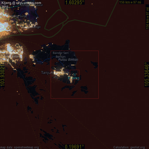
Analysis of Kijang night lights 2016
Square area 10x10 km:
 0%
0%90-99
0%80-89
0.43%70-79
2.81%60-69
1.52%50-59
0%40-49
4.11%30-39
2.16%20-29
1.52%10-19
0.65%0-9
86.8%Square area 50x50 km:
0.03%90-99
0.27%80-89
0.46%70-79
0.66%60-69
1%50-59
0.34%40-49
0.65%30-39
0.26%20-29
0.99%10-19
3.09%0-9
92.26%Clear (daylight) street map image can be seen on geolist.org.
Map coordinates:
1° 36' 10.6" North, 103° 55' 48.8" East
0° 54' 0" North, 104° 37' 60" East
0° 11' 48.9" North, 105° 20' 11.3" East
Some cities around Kijang sort by population:
• Singapore, SG
97.3 km =60.5 mi,  296°
296°
• Batam
73.1 km =45.4 mi,  292°
292°
• Johor Bahru, MY
115.9 km =72 mi, 302°
• Woodlands, SG
111.3 km =69.2 mi, 302°
• Tanjung Pinang
19.5 km =12.1 mi,  275°
275°
• Kampung Pasir Gudang Baru, MY
105.4 km =65.5 mi,  307°
307°
• Ulu Tiram, MY
119.6 km =74.3 mi, 310°
• Kota Tinggi, MY
123.8 km =76.9 mi,  318°
318°
1640044 (p: 41,344)
Sources (retrieved 2019-11-25):
» Earth at Night: Flat Maps 2012, 2016