Tiszaalpár night lights from space
Night Light of Tiszaalpár (Bács-Kiskun) from space (Hungary) Src. Average luminocity for 10x10km area is 0.2232% and for 50x50km: 3.536%.
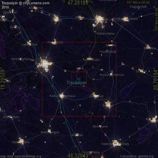
Analysis of Tiszaalpár night lights 2016
Square area 10x10 km:
 0%
0%90-99
0%80-89
0%70-79
0%60-69
0.3%50-59
0%40-49
0%30-39
0%20-29
0%10-19
0%0-9
99.7%Square area 50x50 km:
0.44%90-99
0.63%80-89
0.29%70-79
0.5%60-69
0.5%50-59
0.37%40-49
0.51%30-39
0.52%20-29
0.74%10-19
1.83%0-9
93.68%Clear (daylight) street map image can be seen on geolist.org.
Map coordinates:
47° 17' 30.7" North, 19° 17' 43" East
46° 48' 46" North, 19° 59' 54.3" East
46° 19' 45.9" North, 20° 42' 5.5" East
Some cities around Tiszaalpár sort by population:
• Kecskemét
25.6 km =15.9 mi,  293°
293°
• Kiskunfélegyháza
16.2 km =10.1 mi,  226°
226°
• Nagykőrös
29.7 km =18.5 mi,  325°
325°
• Csongrád
15.6 km =9.7 mi,  135°
135°
• Kunszentmárton
22.3 km =13.9 mi,  82°
82°
• Kistelek
37.9 km =23.5 mi,  182°
182°
• Mindszent
35.3 km =21.9 mi,  155°
155°
• Rákóczifalva
35 km =21.7 mi,  30°
30°
3338787 (p: 5,070)
Sources (retrieved 2019-11-25):
» Earth at Night: Flat Maps 2012, 2016