Mindszent night lights from space
Night Light of Mindszent (Csongrád) from space (Hungary) Src. Average luminocity for 10x10km area is 1.1307% and for 50x50km: 2.6242%.
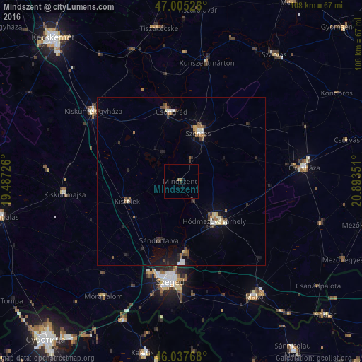
Analysis of Mindszent night lights 2016
Square area 10x10 km:
 0%
0%90-99
0%80-89
0%70-79
0%60-69
0.43%50-59
0.71%40-49
0%30-39
0.71%20-29
0.14%10-19
0.57%0-9
97.44%Square area 50x50 km:
0.19%90-99
0.42%80-89
0.18%70-79
0.24%60-69
0.38%50-59
0.32%40-49
0.42%30-39
0.47%20-29
0.7%10-19
1.55%0-9
95.12%Clear (daylight) street map image can be seen on geolist.org.
Map coordinates:
47° 0' 18.9" North, 19° 29' 14.1" East
46° 31' 25" North, 20° 11' 25.4" East
46° 2' 15.6" North, 20° 53' 36.6" East
Some cities around Mindszent sort by population:
• Szeged
30.3 km =18.8 mi,  186°
186°
• Hódmezővásárhely
16.2 km =10.1 mi,  137°
137°
• Kiskunfélegyháza
33.7 km =20.9 mi,  308°
308°
• Csongrád
21.4 km =13.3 mi,  350°
350°
• Kiskunmajsa
34.7 km =21.6 mi,  263°
263°
• Sándorfalva
19.4 km =12.1 mi,  201°
201°
• Kistelek
17.1 km =10.6 mi,  250°
250°
• Algyő
21 km =13 mi,  176°
176°
717591 (p: 7,243)
Sources (retrieved 2019-11-25):
» Earth at Night: Flat Maps 2012, 2016