Solymár night lights from space
Night Light of Solymár (Pest) from space (Hungary) Src. Average luminocity for 10x10km area is 31.1548% and for 50x50km: 29.314%.
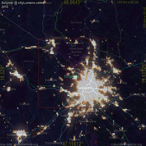
Analysis of Solymár night lights 2016
Square area 10x10 km:
 1.42%
1.42%90-99
5.4%80-89
3.13%70-79
1.99%60-69
5.82%50-59
5.26%40-49
4.4%30-39
10.23%20-29
11.36%10-19
30.82%0-9
20.17%Square area 50x50 km:
10.14%90-99
5.77%80-89
2.27%70-79
2.1%60-69
2.88%50-59
3.33%40-49
3.72%30-39
4.22%20-29
4.36%10-19
10.02%0-9
51.17%Clear (daylight) street map image can be seen on geolist.org.
Map coordinates:
48° 3' 52.2" North, 18° 13' 44.4" East
47° 35' 32.9" North, 18° 55' 55.6" East
47° 6' 58" North, 19° 38' 6.9" East
Some cities around Solymár sort by population:
• Budapest III. kerület
10.2 km =6.3 mi,  123°
123°
• Budapest IV. kerület
12.3 km =7.6 mi,  106°
106°
• Budapest II. kerület
10.5 km =6.5 mi,  140°
140°
• Pomáz
9.1 km =5.7 mi,  52°
52°
• Budakeszi
9.1 km =5.7 mi,  182°
182°
• Pilisvörösvár
2.9 km =1.8 mi,  323°
323°
• Piliscsaba
9 km =5.6 mi,  300°
300°
• Páty
11.4 km =7.1 mi,  222°
222°
3045294 (p: 9,242)
Sources (retrieved 2019-11-25):
» Earth at Night: Flat Maps 2012, 2016