Biatorbágy night lights from space
Night Light of Biatorbágy (Pest) from space (Hungary) Src. Average luminocity for 10x10km area is 18.1974% and for 50x50km: 23.4508%.
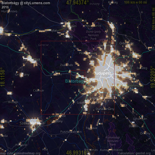
Analysis of Biatorbágy night lights 2016
Square area 10x10 km:
100  2.13%
2.13%
90-99 2.7%
80-89 1.99%
70-79 3.41%
60-69 0%
50-59 1.85%
40-49 0.43%
30-39 2.7%
20-29 4.4%
10-19 30.26%
0-9 50.14%
2.13%90-99
2.7%80-89
1.99%70-79
3.41%60-69
0%50-59
1.85%40-49
0.43%30-39
2.7%20-29
4.4%10-19
30.26%0-9
50.14%Square area 50x50 km:
100 8.39%
90-99 4.25%
80-89 1.58%
70-79 1.77%
60-69 2.2%
50-59 2.63%
40-49 3.15%
30-39 3.51%
20-29 4.43%
10-19 7.45%
0-9 60.64%
8.39%90-99
4.25%80-89
1.58%70-79
1.77%60-69
2.2%50-59
2.63%40-49
3.15%30-39
3.51%20-29
4.43%10-19
7.45%0-9
60.64%Clear (daylight) street map image can be seen on geolist.org.
Map coordinates:
47° 56' 37.5" North, 18° 6' 56.9" East
47° 28' 14.2" North, 18° 49' 8.1" East
46° 59' 35.4" North, 19° 31' 19.4" East
Some cities around Biatorbágy sort by population:
• Érd
11 km =6.8 mi,  139°
139°
• Budaörs
10.5 km =6.5 mi,  95°
95°
• Budakeszi
9.3 km =5.8 mi,  61°
61°
• Törökbálint
8.5 km =5.3 mi,  122°
122°
• Bicske
13.2 km =8.2 mi,  276°
276°
• Tárnok
11 km =6.8 mi,  169°
169°
• Diósd
11.9 km =7.4 mi, 124°
• Páty
5.2 km =3.2 mi,  7°
7°
3055038 (p: 8,632)
Sources (retrieved 2019-11-25):
» Earth at Night: Flat Maps 2012, 2016