Algyő night lights from space
Night Light of Algyő (Csongrád) from space (Hungary) Src. Average luminocity for 10x10km area is 12.1518% and for 50x50km: 5.1428%.
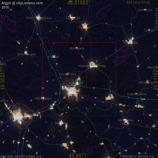
Analysis of Algyő night lights 2016
Square area 10x10 km:
 2.08%
2.08%90-99
0.89%80-89
0.15%70-79
1.19%60-69
1.64%50-59
1.64%40-49
1.93%30-39
1.19%20-29
6.55%10-19
12.65%0-9
70.09%Square area 50x50 km:
0.61%90-99
0.87%80-89
0.57%70-79
0.47%60-69
0.66%50-59
0.5%40-49
0.7%30-39
0.91%20-29
1.53%10-19
3.31%0-9
89.88%Clear (daylight) street map image can be seen on geolist.org.
Map coordinates:
46° 49' 4.9" North, 19° 30' 19.3" East
46° 20' 5" North, 20° 12' 30.6" East
45° 50' 49.6" North, 20° 54' 41.8" East
Some cities around Algyő sort by population:
• Szeged
10.2 km =6.3 mi,  206°
206°
• Hódmezővásárhely
13.2 km =8.2 mi,  46°
46°
• Makó
24.9 km =15.5 mi,  121°
121°
• Kanjiža, RS
32.2 km =20 mi,  202°
202°
• Sándorfalva
8.9 km =5.5 mi,  289°
289°
• Kistelek
23.3 km =14.5 mi,  311°
311°
• Mindszent
21 km =13 mi,  356°
356°
• Mórahalom
28 km =17.4 mi,  242°
242°
7284899 (p: 5,247)
Sources (retrieved 2019-11-25):
» Earth at Night: Flat Maps 2012, 2016