Komárom night lights from space
Night Light of Komárom (Komárom-Esztergom) from space (Hungary) Src. Average luminocity for 10x10km area is 29.7902% and for 50x50km: 4.5114%.
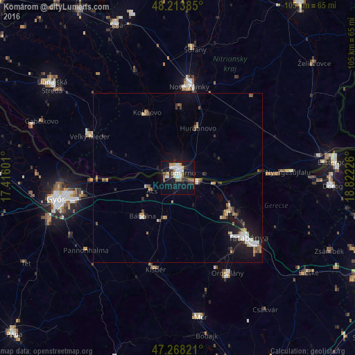
Analysis of Komárom night lights 2016
Square area 10x10 km:
 5.65%
5.65%90-99
7.29%80-89
1.34%70-79
2.53%60-69
3.13%50-59
4.32%40-49
1.19%30-39
4.17%20-29
4.32%10-19
35.57%0-9
30.51%Square area 50x50 km:
0.54%90-99
0.84%80-89
0.3%70-79
0.45%60-69
0.6%50-59
0.63%40-49
0.41%30-39
0.63%20-29
0.56%10-19
4.72%0-9
90.33%Clear (daylight) street map image can be seen on geolist.org.
Map coordinates:
48° 12' 49.9" North, 17° 24' 57.6" East
47° 44' 35.4" North, 18° 7' 8.9" East
47° 16' 5.6" North, 18° 49' 20.1" East
Some cities around Komárom sort by population:
• Tatabánya
27 km =16.8 mi,  130°
130°
• Nové Zámky, SK
27.1 km =16.8 mi,  6°
6°
• Tata
18 km =11.2 mi,  123°
123°
• Kolárovo, SK
22.4 km =13.9 mi,  333°
333°
• Hurbanovo, SK
15.1 km =9.4 mi,  21°
21°
• Ács
8.8 km =5.5 mi,  246°
246°
• Kisbér
27.4 km =17 mi,  193°
193°
• Lábatlan
28.2 km =17.5 mi,  89°
89°
3049519 (p: 19,646)
Sources (retrieved 2019-11-25):
» Earth at Night: Flat Maps 2012, 2016