Ouanaminthe night lights from space
Night Light of Ouanaminthe (Nord-Est) from space (Haiti) Src. Average luminocity for 10x10km area is 8.7975% and for 50x50km: 0.8891%.
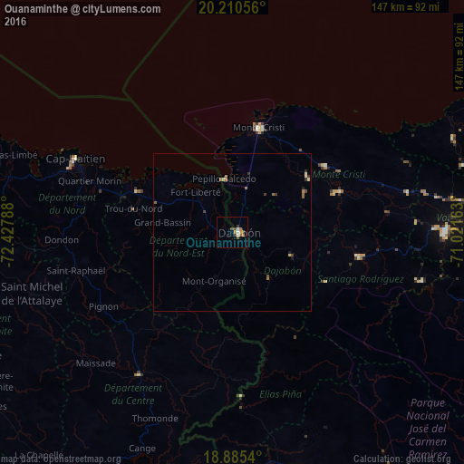
Analysis of Ouanaminthe night lights 2016
Square area 10x10 km:
 0.21%
0.21%90-99
2.27%80-89
0.62%70-79
1.03%60-69
2.48%50-59
1.24%40-49
2.07%30-39
1.65%20-29
0%10-19
0%0-9
88.43%Square area 50x50 km:
0.01%90-99
0.15%80-89
0.12%70-79
0.04%60-69
0.32%50-59
0.15%40-49
0.18%30-39
0.24%20-29
0.06%10-19
0.09%0-9
98.64%Clear (daylight) street map image can be seen on geolist.org.
Map coordinates:
20° 12' 38" North, 72° 25' 40.4" West
19° 32' 57.6" North, 71° 43' 29.1" West
18° 53' 7.4" North, 71° 1' 17.9" West
Some cities around Ouanaminthe sort by population:
• San Fernando de Monte Cristi, DO
34.2 km =21.3 mi,  13°
13°
• Dajabón, DO
1.7 km =1.1 mi,  92°
92°
• Sabaneta, DO
41 km =25.5 mi,  101°
101°
• Villa Vásquez, DO
36.1 km =22.4 mi,  53°
53°
• Fort Liberté
17.3 km =10.7 mi,  316°
316°
• Trou du Nord
32.3 km =20.1 mi,  283°
283°
• Las Matas de Santa Cruz, DO
26.7 km =16.6 mi,  59°
59°
• Loma de Cabrera, DO
18.4 km =11.4 mi,  134°
134°
3719436 (p: 10,118)
Sources (retrieved 2019-11-25):
» Earth at Night: Flat Maps 2012, 2016