Villa Vásquez night lights from space
Night Light of Villa Vásquez (Monte Cristi) from space (Dominican Republic) Src. Average luminocity for 10x10km area is 5.0207% and for 50x50km: 1.1993%.
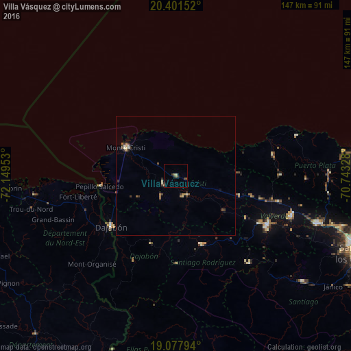
Analysis of Villa Vásquez night lights 2016
Square area 10x10 km:
 0%
0%90-99
0.62%80-89
0.62%70-79
1.03%60-69
1.03%50-59
0.62%40-49
0.83%30-39
1.24%20-29
1.03%10-19
0%0-9
92.98%Square area 50x50 km:
0%90-99
0.22%80-89
0.15%70-79
0.19%60-69
0.23%50-59
0.14%40-49
0.15%30-39
0.41%20-29
0.15%10-19
0.11%0-9
98.25%Clear (daylight) street map image can be seen on geolist.org.
Map coordinates:
20° 24' 5.5" North, 72° 8' 58.3" West
19° 44' 28" North, 71° 26' 47" West
19° 4' 40.6" North, 70° 44' 35.8" West
Some cities around Villa Vásquez sort by population:
• San Fernando de Monte Cristi
24 km =14.9 mi,  299°
299°
• Dajabón
34.8 km =21.6 mi,  232°
232°
• Sabaneta
31.3 km =19.4 mi,  159°
159°
• Fort Liberté, HT
41.9 km =26 mi,  257°
257°
• Las Matas de Santa Cruz
9.9 km =6.2 mi,  218°
218°
• Ouanaminthe, HT
36.1 km =22.4 mi, 233°
• Laguna Salada
39.2 km =24.4 mi,  104°
104°
• Loma de Cabrera
37.8 km =23.5 mi,  205°
205°
3491905 (p: 11,642)
Sources (retrieved 2019-11-25):
» Earth at Night: Flat Maps 2012, 2016