Slatina night lights from space
Night Light of Slatina (Virovitičk-Podravska) from space (Croatia) Src. Average luminocity for 10x10km area is 11.1152% and for 50x50km: 1.3138%.
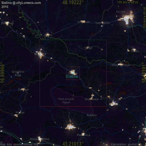
Analysis of Slatina night lights 2016
Square area 10x10 km:
 1.36%
1.36%90-99
1.21%80-89
2.12%70-79
1.36%60-69
2.42%50-59
0.76%40-49
1.21%30-39
1.36%20-29
0.3%10-19
0.15%0-9
87.73%Square area 50x50 km:
0.11%90-99
0.14%80-89
0.12%70-79
0.12%60-69
0.38%50-59
0.16%40-49
0.23%30-39
0.17%20-29
0.23%10-19
0.33%0-9
97.99%Clear (daylight) street map image can be seen on geolist.org.
Map coordinates:
46° 11' 32" North, 16° 59' 58.8" East
45° 42' 12" North, 17° 42' 10" East
45° 12' 36.5" North, 18° 24' 21.3" East
Some cities around Slatina sort by population:
• Požega
40.4 km =25.1 mi,  181°
181°
• Virovitica
28.6 km =17.8 mi,  300°
300°
• Barcs, HU
34.2 km =21.3 mi,  326°
326°
• Szigetvár, HU
39.2 km =24.4 mi,  11°
11°
• Daruvar
39.2 km =24.4 mi,  251°
251°
• Našice
38.3 km =23.8 mi,  128°
128°
• Szentlőrinc, HU
43.4 km =27 mi,  30°
30°
• Pitomača
45.8 km =28.5 mi,  306°
306°
3192932 (p: 10,973)
Sources (retrieved 2019-11-25):
» Earth at Night: Flat Maps 2012, 2016