Daruvar night lights from space
Night Light of Daruvar (Bjelovarsko-Bilogorska) from space (Croatia) Src. Average luminocity for 10x10km area is 2.147% and for 50x50km: 0.5905%.
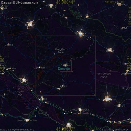
Analysis of Daruvar night lights 2016
Square area 10x10 km:
 0%
0%90-99
0%80-89
0.45%70-79
0.15%60-69
0.3%50-59
1.82%40-49
0.3%30-39
0.3%20-29
0.3%10-19
0%0-9
96.36%Square area 50x50 km:
0%90-99
0.06%80-89
0.07%70-79
0.1%60-69
0.14%50-59
0.12%40-49
0.09%30-39
0.05%20-29
0.14%10-19
0.18%0-9
99.04%Clear (daylight) street map image can be seen on geolist.org.
Map coordinates:
46° 4' 49.6" North, 16° 31' 18.8" East
45° 35' 26" North, 17° 13' 30" East
45° 5' 46.9" North, 17° 55' 41.3" East
Some cities around Daruvar sort by population:
• Bjelovar
45 km =28 mi,  319°
319°
• Virovitica
29.5 km =18.3 mi,  24°
24°
• Kutina
36.8 km =22.9 mi,  249°
249°
• Nova Gradiška
39.3 km =24.4 mi,  161°
161°
• Barcs, HU
44.9 km =27.9 mi, 23°
• Slatina
39.2 km =24.4 mi,  71°
71°
• Novska
33.9 km =21.1 mi,  214°
214°
• Pitomača
40 km =24.9 mi,  0°
0°
3202184 (p: 9,863)
Sources (retrieved 2019-11-25):
» Earth at Night: Flat Maps 2012, 2016