Virovitica night lights from space
Night Light of Virovitica (Virovitičk-Podravska) from space (Croatia) Src. Average luminocity for 10x10km area is 17.5298% and for 50x50km: 1.5669%.
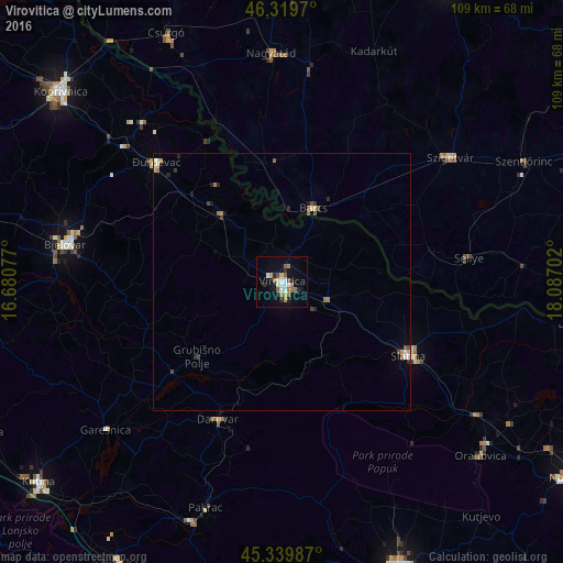
Analysis of Virovitica night lights 2016
Square area 10x10 km:
 1.93%
1.93%90-99
3.13%80-89
1.93%70-79
1.64%60-69
3.27%50-59
2.98%40-49
1.19%30-39
0.45%20-29
3.27%10-19
11.9%0-9
68.3%Square area 50x50 km:
0.13%90-99
0.23%80-89
0.2%70-79
0.17%60-69
0.28%50-59
0.23%40-49
0.22%30-39
0.13%20-29
0.32%10-19
0.61%0-9
97.47%Clear (daylight) street map image can be seen on geolist.org.
Map coordinates:
46° 19' 10.9" North, 16° 40' 50.8" East
45° 49' 55" North, 17° 23' 2" East
45° 20' 23.5" North, 18° 5' 13.3" East
Some cities around Virovitica sort by population:
• Bjelovar
42.1 km =26.2 mi,  280°
280°
• Barcs, HU
15.4 km =9.6 mi,  22°
22°
• Nagyatád, HU
44.3 km =27.5 mi,  357°
357°
• Szigetvár, HU
40.5 km =25.2 mi,  53°
53°
• Slatina
28.6 km =17.8 mi,  120°
120°
• Daruvar
29.5 km =18.3 mi,  204°
204°
• Đurđevac
33.6 km =20.9 mi,  313°
313°
• Pitomača
17.8 km =11.1 mi,  317°
317°
3187694 (p: 15,665)
Sources (retrieved 2019-11-25):
» Earth at Night: Flat Maps 2012, 2016