Popovača night lights from space
Night Light of Popovača (Sisačko-Moslavačka) from space (Croatia) Src. Average luminocity for 10x10km area is 2.8152% and for 50x50km: 3.3277%.
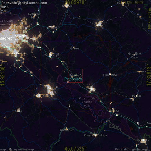
Analysis of Popovača night lights 2016
Square area 10x10 km:
 0%
0%90-99
0%80-89
0%70-79
0%60-69
0.61%50-59
1.82%40-49
1.21%30-39
0.61%20-29
0.61%10-19
1.21%0-9
93.94%Square area 50x50 km:
0.44%90-99
0.57%80-89
0.28%70-79
0.29%60-69
0.45%50-59
0.38%40-49
0.35%30-39
0.56%20-29
0.71%10-19
2.59%0-9
93.37%Clear (daylight) street map image can be seen on geolist.org.
Map coordinates:
46° 3' 35.2" North, 15° 55' 18.8" East
45° 34' 11" North, 16° 37' 30" East
45° 4' 31.3" North, 17° 19' 41.3" East
Some cities around Popovača sort by population:
• Sisak
22.4 km =13.9 mi,  239°
239°
• Velika Gorica
45.6 km =28.3 mi,  290°
290°
• Bjelovar
40.5 km =25.2 mi,  25°
25°
• Kutina
16.1 km =10 mi,  130°
130°
• Petrinja
30 km =18.6 mi, 240°
• Kozarska Dubica, BA
46 km =28.6 mi,  161°
161°
• Daruvar
46.8 km =29.1 mi,  87°
87°
• Novska
37.5 km =23.3 mi, 132°
3192724 (p: 12,000)
Sources (retrieved 2019-11-25):
» Earth at Night: Flat Maps 2012, 2016