Ogulin night lights from space
Night Light of Ogulin (Karlovačka) from space (Croatia) Src. Average luminocity for 10x10km area is 9.6333% and for 50x50km: 1.4502%.
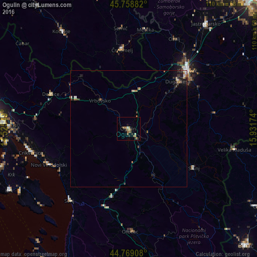
Analysis of Ogulin night lights 2016
Square area 10x10 km:
 0.3%
0.3%90-99
0.3%80-89
1.06%70-79
2.12%60-69
3.18%50-59
1.82%40-49
1.36%30-39
2.12%20-29
0.76%10-19
0.45%0-9
86.52%Square area 50x50 km:
0.09%90-99
0.17%80-89
0.17%70-79
0.16%60-69
0.39%50-59
0.11%40-49
0.25%30-39
0.28%20-29
0.35%10-19
0.78%0-9
97.25%Clear (daylight) street map image can be seen on geolist.org.
Map coordinates:
45° 45' 31.8" North, 14° 31' 31.8" East
45° 15' 58" North, 15° 13' 43" East
44° 46' 8.7" North, 15° 55' 54.3" East
Some cities around Ogulin sort by population:
• Karlovac
35.5 km =22.1 mi,  45°
45°
• Crikvenica
43.1 km =26.8 mi,  256°
256°
• Črnomelj, SI
34.1 km =21.2 mi,  354°
354°
• Senj
39.8 km =24.7 mi,  219°
219°
• Novi Vinodolski
37.7 km =23.4 mi,  245°
245°
• Metlika, SI
42.9 km =26.7 mi,  8°
8°
• Semič, SI
42.4 km =26.3 mi,  355°
355°
• Kostel, SI
36.7 km =22.8 mi,  317°
317°
3194183 (p: 8,755)
Sources (retrieved 2019-11-25):
» Earth at Night: Flat Maps 2012, 2016