Makarska night lights from space
Night Light of Makarska (Split-Dalmatia) from space (Croatia) Src. Average luminocity for 10x10km area is 13.1606% and for 50x50km: 3.1419%.
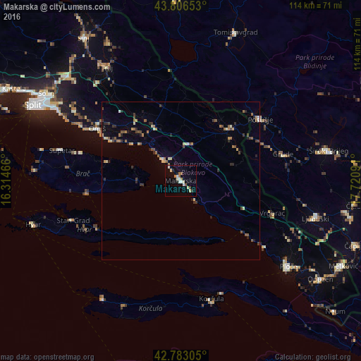
Analysis of Makarska night lights 2016
Square area 10x10 km:
 1.67%
1.67%90-99
2.88%80-89
2.12%70-79
0.3%60-69
2.42%50-59
1.21%40-49
0.15%30-39
0.61%20-29
1.36%10-19
1.06%0-9
86.21%Square area 50x50 km:
0.14%90-99
0.39%80-89
0.39%70-79
0.31%60-69
0.53%50-59
0.54%40-49
0.49%30-39
0.44%20-29
0.79%10-19
0.47%0-9
95.52%Clear (daylight) street map image can be seen on geolist.org.
Map coordinates:
43° 48' 23.5" North, 16° 18' 52.8" East
43° 17' 49" North, 17° 1' 4" East
42° 46' 59" North, 17° 43' 15.3" East
Some cities around Makarska sort by population:
• Split
52.3 km =32.5 mi,  296°
296°
• Solin
50.4 km =31.3 mi, 302°
• Ljubuški, BA
44.1 km =27.4 mi,  104°
104°
• Široki Brijeg, BA
47.6 km =29.6 mi,  78°
78°
• Podstrana
43.3 km =26.9 mi, 299°
• Tomislavgrad, BA
49.8 km =30.9 mi,  19°
19°
• Omiš
31.3 km =19.4 mi, 301°
• Podhum, BA
47.4 km =29.5 mi,  358°
358°
3195890 (p: 13,446)
Sources (retrieved 2019-11-25):
» Earth at Night: Flat Maps 2012, 2016