Široki Brijeg night lights from space
Night Light of Široki Brijeg (Federation of B&H) from space (Bosnia and Herzegovina) Src. Average luminocity for 10x10km area is 13.7984% and for 50x50km: 6.3284%.
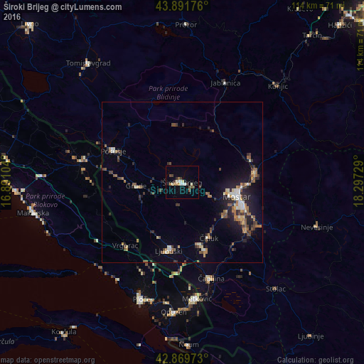
Analysis of Široki Brijeg night lights 2016
Square area 10x10 km:
 1.27%
1.27%90-99
3.17%80-89
1.59%70-79
0.48%60-69
2.38%50-59
1.43%40-49
2.7%30-39
1.75%20-29
0.48%10-19
0.16%0-9
84.6%Square area 50x50 km:
0.46%90-99
0.8%80-89
0.65%70-79
0.67%60-69
1.04%50-59
1.07%40-49
1.04%30-39
1.02%20-29
1.76%10-19
3.65%0-9
87.83%Clear (daylight) street map image can be seen on geolist.org.
Map coordinates:
43° 53' 30.3" North, 16° 53' 27.7" East
43° 22' 58.4" North, 17° 35' 39" East
42° 52' 11" North, 18° 17' 50.2" East
Some cities around Široki Brijeg sort by population:
• Mostar
17.8 km =11.1 mi,  104°
104°
• Ljubuški
21.1 km =13.1 mi,  190°
190°
• Potoci
23.2 km =14.4 mi,  82°
82°
• Čapljina
30 km =18.6 mi,  165°
165°
• Jablanica
33.7 km =20.9 mi,  23°
23°
• Crnići
35.5 km =22.1 mi,  141°
141°
• Čitluk
19.2 km =11.9 mi,  153°
153°
• Rodoč
18.5 km =11.5 mi,  114°
114°
3196428 (p: 9,370)
Sources (retrieved 2019-11-25):
» Earth at Night: Flat Maps 2012, 2016