Podhum night lights from space
Night Light of Podhum (Federation of B&H) from space (Bosnia and Herzegovina) Src. Average luminocity for 10x10km area is 0.047% and for 50x50km: 1.4928%.
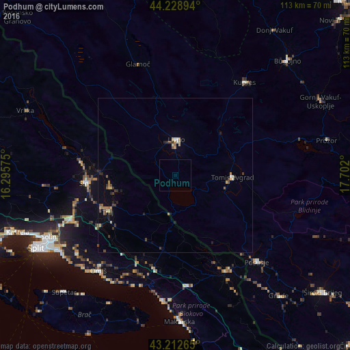
Analysis of Podhum night lights 2016
Square area 10x10 km:
 0%
0%90-99
0%80-89
0%70-79
0%60-69
0%50-59
0%40-49
0%30-39
0%20-29
0%10-19
0%0-9
100%Square area 50x50 km:
0.04%90-99
0.16%80-89
0.2%70-79
0.22%60-69
0.23%50-59
0.18%40-49
0.3%30-39
0.27%20-29
0.38%10-19
0.23%0-9
97.78%Clear (daylight) street map image can be seen on geolist.org.
Map coordinates:
44° 13' 44.2" North, 16° 17' 44.7" East
43° 43' 22.6" North, 16° 59' 55.9" East
43° 12' 45.5" North, 17° 42' 7.2" East
Some cities around Podhum sort by population:
• Solin, HR
45.3 km =28.1 mi,  243°
243°
• Makarska, HR
47.4 km =29.5 mi,  178°
178°
• Livno
11.6 km =7.2 mi,  3°
3°
• Sinj, HR
29 km =18 mi,  265°
265°
• Prozor
50.2 km =31.2 mi,  77°
77°
• Podstrana, HR
44.7 km =27.8 mi,  233°
233°
• Tomislavgrad
18.2 km =11.3 mi,  91°
91°
• Omiš, HR
39.8 km =24.7 mi,  218°
218°
3193008 (p: 5,801)
Sources (retrieved 2019-11-25):
» Earth at Night: Flat Maps 2012, 2016