Gorišnica night lights from space
Night Light of Gorišnica from space (Slovenia) Src. Average luminocity for 10x10km area is 1.0952% and for 50x50km: 4.6681%.
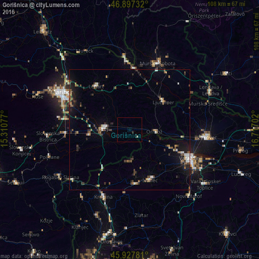
Analysis of Gorišnica night lights 2016
Square area 10x10 km:
100  0%
0%
90-99 0.6%
80-89 0%
70-79 0%
60-69 0%
50-59 0%
40-49 0%
30-39 0.6%
20-29 0%
10-19 1.19%
0-9 97.62%
0%90-99
0.6%80-89
0%70-79
0%60-69
0%50-59
0%40-49
0%30-39
0.6%20-29
0%10-19
1.19%0-9
97.62%Square area 50x50 km:
100 0.48%
90-99 0.55%
80-89 0.25%
70-79 0.36%
60-69 0.56%
50-59 0.99%
40-49 0.84%
30-39 0.76%
20-29 1.3%
10-19 2.74%
0-9 91.18%
0.48%90-99
0.55%80-89
0.25%70-79
0.36%60-69
0.56%50-59
0.99%40-49
0.84%30-39
0.76%20-29
1.3%10-19
2.74%0-9
91.18%Clear (daylight) street map image can be seen on geolist.org.
Map coordinates:
46° 53' 50.4" North, 15° 18' 38.8" East
46° 24' 53" North, 16° 0' 50" East
45° 55' 40.1" North, 16° 43' 1.3" East
Some cities around Gorišnica sort by population:
• Ormož
10.8 km =6.7 mi,  91°
91°
• Dornava
5.2 km =3.2 mi,  297°
297°
• Videm pri Ptuju
9.7 km =6 mi,  238°
238°
• Markovci
6.9 km =4.3 mi,  252°
252°
• Cirkulane
8 km =5 mi,  190°
190°
• Juršinci
8.4 km =5.2 mi,  337°
337°
• Sveti Tomaž
9.4 km =5.8 mi,  34°
34°
• Zavrč
3.8 km =2.4 mi,  133°
133°
3200307 (p: 788)
Sources (retrieved 2019-11-25):
» Earth at Night: Flat Maps 2012, 2016