Villa de San Francisco night lights from space
Night Light of Villa de San Francisco (Francisco Morazán) from space (Honduras) Src. Average luminocity for 10x10km area is 2.7641% and for 50x50km: 5.2376%.
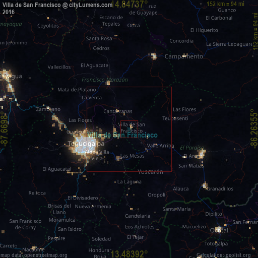
Analysis of Villa de San Francisco night lights 2016
Square area 10x10 km:
 0%
0%90-99
0%80-89
0%70-79
0.22%60-69
2.38%50-59
0%40-49
0.87%30-39
0%20-29
0%10-19
0%0-9
96.54%Square area 50x50 km:
1.27%90-99
0.59%80-89
0.13%70-79
0.26%60-69
0.81%50-59
1.13%40-49
0.99%30-39
1.18%20-29
1.54%10-19
2.46%0-9
89.63%Clear (daylight) street map image can be seen on geolist.org.
Map coordinates:
14° 50' 50.5" North, 87° 40' 11.3" West
14° 10' 0" North, 86° 58' 0" West
13° 29' 2.1" North, 86° 15' 48.8" West
Some cities around Villa de San Francisco sort by population:
• Tegucigalpa
27.6 km =17.1 mi,  249°
249°
• Danlí
43.9 km =27.3 mi,  109°
109°
• El Paraíso
56 km =34.8 mi,  126°
126°
• La Paz
78.6 km =48.8 mi,  282°
282°
• Talanga
28.8 km =17.9 mi,  334°
334°
• Guaimaca
43.9 km =27.3 mi,  21°
21°
• Campamento
54.6 km =33.9 mi,  38°
38°
• Yuscarán
27.6 km =17.1 mi,  153°
153°
3600338 (p: 5,914)
Sources (retrieved 2019-11-25):
» Earth at Night: Flat Maps 2012, 2016