Santa Cruz de Yojoa night lights from space
Night Light of Santa Cruz de Yojoa (Cortés) from space (Honduras) Src. Average luminocity for 10x10km area is 7.1446% and for 50x50km: 2.3506%.
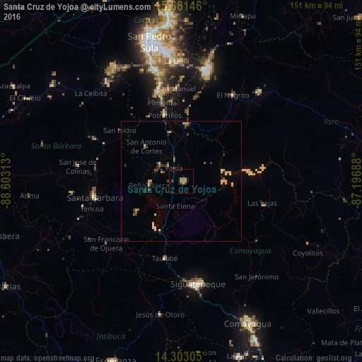
Analysis of Santa Cruz de Yojoa night lights 2016
Square area 10x10 km:
 0%
0%90-99
0%80-89
0.83%70-79
2.07%60-69
2.69%50-59
0.21%40-49
2.07%30-39
0.41%20-29
1.24%10-19
2.89%0-9
87.6%Square area 50x50 km:
0%90-99
0.21%80-89
0.58%70-79
0.43%60-69
0.33%50-59
0.18%40-49
0.43%30-39
0.38%20-29
0.51%10-19
0.49%0-9
96.46%Clear (daylight) street map image can be seen on geolist.org.
Map coordinates:
15° 39' 41.3" North, 88° 36' 11.3" West
14° 58' 60" North, 87° 54' 0" West
14° 18' 11" North, 87° 11' 48.8" West
Some cities around Santa Cruz de Yojoa sort by population:
• Siguatepeque
43.2 km =26.8 mi,  170°
170°
• Villanueva
38.6 km =24 mi,  343°
343°
• Potrerillos
28.7 km =17.8 mi,  345°
345°
• El Negrito
42.8 km =26.6 mi,  30°
30°
• Pimienta Vieja
28.7 km =17.8 mi, 345°
• Agua Blanca Sur
29.7 km =18.5 mi,  3°
3°
• Las Vegas, Santa Barbara
22.2 km =13.8 mi,  237°
237°
• San Manuel
39 km =24.2 mi,  357°
357°
3601627 (p: 10,230)
Sources (retrieved 2019-11-25):
» Earth at Night: Flat Maps 2012, 2016