El Negrito night lights from space
Night Light of El Negrito (Yoro) from space (Honduras) Src. Average luminocity for 10x10km area is 3.9008% and for 50x50km: 6.1057%.
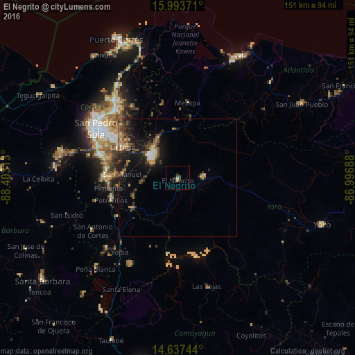
Analysis of El Negrito night lights 2016
Square area 10x10 km:
 0%
0%90-99
0.83%80-89
0%70-79
0%60-69
0.83%50-59
0%40-49
2.07%30-39
1.24%20-29
2.27%10-19
0.21%0-9
92.56%Square area 50x50 km:
0.31%90-99
0.55%80-89
0.77%70-79
0.75%60-69
0.81%50-59
1.03%40-49
1.22%30-39
1.6%20-29
1.91%10-19
5.76%0-9
85.29%Clear (daylight) street map image can be seen on geolist.org.
Map coordinates:
15° 59' 37.4" North, 88° 24' 11.3" West
15° 19' 0" North, 87° 42' 0" West
14° 38' 14.8" North, 86° 59' 48.8" West
Some cities around El Negrito sort by population:
• El Progreso
14.2 km =8.8 mi,  310°
310°
• La Lima
26.6 km =16.5 mi,  299°
299°
• Potrerillos
30.1 km =18.7 mi,  252°
252°
• Morazán
10.7 km =6.6 mi,  90°
90°
• Pimienta Vieja
30.1 km =18.7 mi, 252°
• Agua Blanca Sur
21 km =13 mi, 249°
• San Manuel
23.3 km =14.5 mi,  274°
274°
• Mezapa
30.1 km =18.7 mi,  10°
10°
3611150 (p: 9,303)
Sources (retrieved 2019-11-25):
» Earth at Night: Flat Maps 2012, 2016