Las Vegas, Santa Barbara night lights from space
Night Light of Las Vegas, Santa Barbara (Santa Bárbara) from space (Honduras) Src. Average luminocity for 10x10km area is 3.6612% and for 50x50km: 2.1854%.
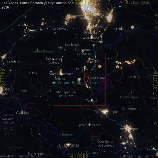
Analysis of Las Vegas, Santa Barbara night lights 2016
Square area 10x10 km:
 0%
0%90-99
0%80-89
0.41%70-79
0.41%60-69
2.48%50-59
0%40-49
0.41%30-39
1.03%20-29
1.03%10-19
0%0-9
94.21%Square area 50x50 km:
0.03%90-99
0.26%80-89
0.31%70-79
0.26%60-69
0.42%50-59
0.3%40-49
0.5%30-39
0.48%20-29
0.54%10-19
0.55%0-9
96.36%Clear (daylight) street map image can be seen on geolist.org.
Map coordinates:
15° 33' 17.9" North, 88° 46' 40.3" West
14° 52' 35.4" North, 88° 4' 29" West
14° 11' 45.2" North, 87° 22' 17.8" West
Some cities around Las Vegas, Santa Barbara sort by population:
• Siguatepeque
40.2 km =25 mi,  139°
139°
• Potrerillos
41.3 km =25.7 mi,  16°
16°
• Santa Bárbara
18 km =11.2 mi,  285°
285°
• Santa Cruz de Yojoa
22.2 km =13.8 mi,  57°
57°
• Pimienta Vieja
41.3 km =25.7 mi, 16°
• Agua Blanca Sur
46.3 km =28.8 mi,  26°
26°
• Jesús de Otoro
44.8 km =27.8 mi,  167°
167°
• San Luis
40.3 km =25 mi,  304°
304°
3606251 (p: 7,487)
Sources (retrieved 2019-11-25):
» Earth at Night: Flat Maps 2012, 2016