Morazán night lights from space
Night Light of Morazán (Yoro) from space (Honduras) Src. Average luminocity for 10x10km area is 6.5599% and for 50x50km: 2.8338%.
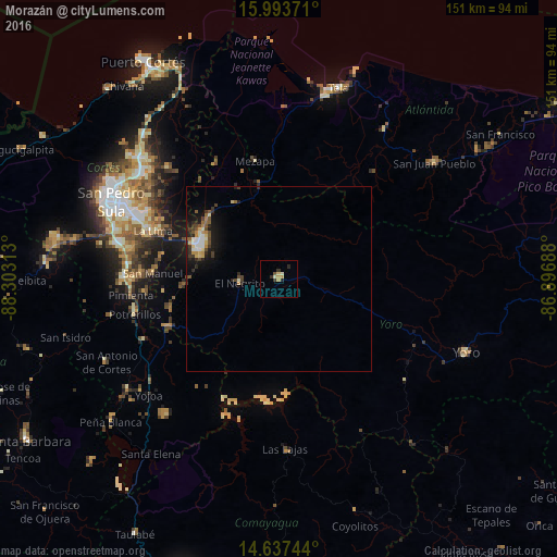
Analysis of Morazán night lights 2016
Square area 10x10 km:
 0%
0%90-99
1.45%80-89
1.03%70-79
2.48%60-69
0%50-59
0.41%40-49
0.41%30-39
2.07%20-29
2.07%10-19
0%0-9
90.08%Square area 50x50 km:
0.26%90-99
0.45%80-89
0.38%70-79
0.39%60-69
0.25%50-59
0.3%40-49
0.54%30-39
0.64%20-29
0.79%10-19
1.95%0-9
94.06%Clear (daylight) street map image can be seen on geolist.org.
Map coordinates:
15° 59' 37.4" North, 88° 18' 11.3" West
15° 19' 0" North, 87° 36' 0" West
14° 38' 14.8" North, 86° 53' 48.8" West
Some cities around Morazán sort by population:
• El Progreso
23.4 km =14.5 mi,  293°
293°
• La Lima
36.3 km =22.6 mi, 290°
• Santa Rita
37.8 km =23.5 mi,  116°
116°
• El Negrito
10.7 km =6.6 mi,  270°
270°
• Pimienta Vieja
40.4 km =25.1 mi,  256°
256°
• Agua Blanca Sur
31.3 km =19.4 mi, 256°
• San Manuel
34 km =21.1 mi, 273°
• Mezapa
30.1 km =18.7 mi,  349°
349°
3604584 (p: 11,076)
Sources (retrieved 2019-11-25):
» Earth at Night: Flat Maps 2012, 2016