Santa María de Jesús night lights from space
Night Light of Santa María de Jesús (Sacatepéquez) from space (Guatemala) Src. Average luminocity for 10x10km area is 12.0519% and for 50x50km: 26.6393%.
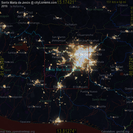
Analysis of Santa María de Jesús night lights 2016
Square area 10x10 km:
 0%
0%90-99
0%80-89
0%70-79
0%60-69
3.03%50-59
3.9%40-49
0%30-39
1.08%20-29
0.65%10-19
37.23%0-9
54.11%Square area 50x50 km:
5.32%90-99
5.51%80-89
3.75%70-79
2.98%60-69
4.02%50-59
3.27%40-49
3.04%30-39
2.9%20-29
4.3%10-19
12.12%0-9
52.79%Clear (daylight) street map image can be seen on geolist.org.
Map coordinates:
15° 10' 27.2" North, 91° 24' 48.6" West
14° 29' 40.3" North, 90° 42' 37.3" West
13° 48' 45.9" North, 90° 0' 26.1" West
Some cities around Santa María de Jesús sort by population:
• Amatitlán
8.3 km =5.2 mi,  103°
103°
• Antigua Guatemala
7.8 km =4.8 mi,  340°
340°
• Palín
10.2 km =6.3 mi,  171°
171°
• Ciudad Vieja
6.6 km =4.1 mi,  299°
299°
• Jocotenango
9.8 km =6.1 mi, 342°
• San Miguel Dueñas
10.1 km =6.3 mi,  287°
287°
• San Antonio Aguas Calientes
9.5 km =5.9 mi,  307°
307°
• Magdalena Milpas Altas
7.1 km =4.4 mi,  32°
32°
3589253 (p: 15,529)
Sources (retrieved 2019-11-25):
» Earth at Night: Flat Maps 2012, 2016