Oratorio night lights from space
Night Light of Oratorio (Santa Rosa) from space (Guatemala) Src. Average luminocity for 10x10km area is 0.9762% and for 50x50km: 0.8741%.
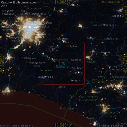
Analysis of Oratorio night lights 2016
Square area 10x10 km:
 0%
0%90-99
0%80-89
0%70-79
0%60-69
0.87%50-59
0%40-49
0%30-39
0.87%20-29
0%10-19
0%0-9
98.27%Square area 50x50 km:
0%90-99
0.01%80-89
0.16%70-79
0.02%60-69
0.14%50-59
0.07%40-49
0.29%30-39
0.6%20-29
0.33%10-19
0.18%0-9
98.21%Clear (daylight) street map image can be seen on geolist.org.
Map coordinates:
14° 54' 30.9" North, 90° 52' 44.3" West
14° 13' 41" North, 90° 10' 33" West
13° 32' 43.8" North, 89° 28' 21.8" West
Some cities around Oratorio sort by population:
• Barberena
21.9 km =13.6 mi,  293°
293°
• Cuilapa
14.3 km =8.9 mi, 292°
• Jalpatagua
20.4 km =12.7 mi,  118°
118°
• Nueva Santa Rosa
20.2 km =12.6 mi,  327°
327°
• Casillas
22.5 km =14 mi,  341°
341°
• Moyuta
23.4 km =14.5 mi,  154°
154°
• San José Acatempa
6.7 km =4.2 mi,  51°
51°
• Santa Rosa de Lima
22 km =13.7 mi,  324°
324°
3592019 (p: 10,155)
Sources (retrieved 2019-11-25):
» Earth at Night: Flat Maps 2012, 2016