Guazacapán night lights from space
Night Light of Guazacapán (Santa Rosa) from space (Guatemala) Src. Average luminocity for 10x10km area is 2.4935% and for 50x50km: 0.3638%.
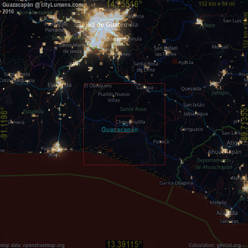
Analysis of Guazacapán night lights 2016
Square area 10x10 km:
 0%
0%90-99
0%80-89
0%70-79
0%60-69
0%50-59
0.87%40-49
1.52%30-39
2.6%20-29
1.08%10-19
0%0-9
93.94%Square area 50x50 km:
0%90-99
0.01%80-89
0.03%70-79
0%60-69
0.12%50-59
0.03%40-49
0.11%30-39
0.28%20-29
0.17%10-19
0.12%0-9
99.14%Clear (daylight) street map image can be seen on geolist.org.
Map coordinates:
14° 45' 18.6" North, 91° 7' 11.3" West
14° 4' 27" North, 90° 25' 0" West
13° 23' 28.1" North, 89° 42' 48.8" West
Some cities around Guazacapán sort by population:
• Barberena
26.6 km =16.5 mi,  12°
12°
• Cuilapa
25.8 km =16 mi,  29°
29°
• Chiquimulilla
3.5 km =2.2 mi,  72°
72°
• Oratorio
31.1 km =19.3 mi,  56°
56°
• Moyuta
36.4 km =22.6 mi,  96°
96°
• Taxisco
5.6 km =3.5 mi,  262°
262°
• Santa Cruz Naranjo
35.3 km =21.9 mi, 8°
• Santa Rosa de Lima
37.3 km =23.2 mi,  20°
20°
3595503 (p: 7,080)
Sources (retrieved 2019-11-25):
» Earth at Night: Flat Maps 2012, 2016