Taxisco night lights from space
Night Light of Taxisco (Santa Rosa) from space (Guatemala) Src. Average luminocity for 10x10km area is 0.0433% and for 50x50km: 0.3188%.
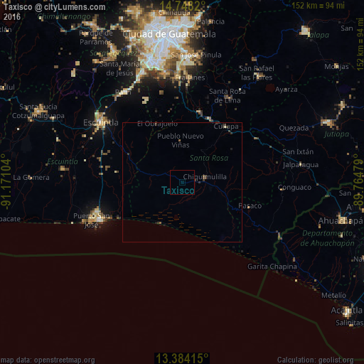
Analysis of Taxisco night lights 2016
Square area 10x10 km:
 0%
0%90-99
0%80-89
0%70-79
0%60-69
0%50-59
0%40-49
0%30-39
0%20-29
0%10-19
0%0-9
100%Square area 50x50 km:
0%90-99
0.01%80-89
0.03%70-79
0%60-69
0.07%50-59
0.03%40-49
0.09%30-39
0.28%20-29
0.17%10-19
0.12%0-9
99.21%Clear (daylight) street map image can be seen on geolist.org.
Map coordinates:
14° 44' 53.5" North, 91° 10' 15.7" West
14° 4' 1.9" North, 90° 28' 4.5" West
13° 23' 2.9" North, 89° 45' 53.2" West
Some cities around Taxisco sort by population:
• Barberena
29.1 km =18.1 mi,  23°
23°
• Cuilapa
29.5 km =18.3 mi,  38°
38°
• Chiquimulilla
9.1 km =5.7 mi,  78°
78°
• Oratorio
36.2 km =22.5 mi,  60°
60°
• Nueva Santa Rosa
40.6 km =25.2 mi,  30°
30°
• Guazacapán
5.6 km =3.5 mi, 82°
• Santa Cruz Naranjo
37.2 km =23.1 mi, 16°
• Santa Rosa de Lima
40.2 km =25 mi, 27°
3588491 (p: 6,518)
Sources (retrieved 2019-11-25):
» Earth at Night: Flat Maps 2012, 2016