Lykóvrysi night lights from space
Night Light of Lykóvrysi (Attica) from space (Greece) Src. Average luminocity for 10x10km area is 97.9919% and for 50x50km: 47.0423%.
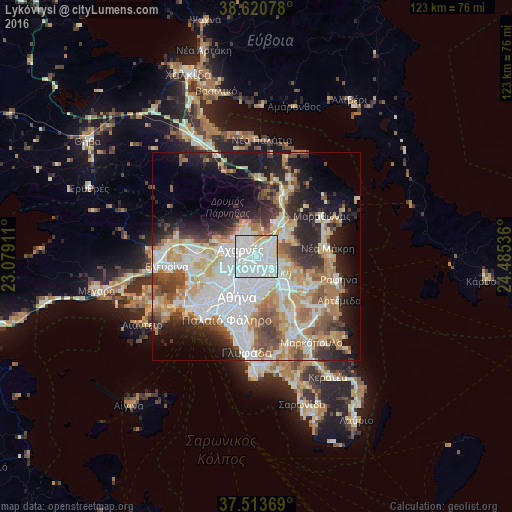
Analysis of Lykóvrysi night lights 2016
Square area 10x10 km:
 68.83%
90-99
24.68%80-89
2.27%70-79
3.9%60-69
0.32%50-59
0%40-49
0%30-39
0%20-29
0%10-19
0%0-9
0%Square area 50x50 km:
13.04%90-99
10.51%80-89
4.84%70-79
6.33%60-69
6.46%50-59
4.76%40-49
5.12%30-39
4.82%20-29
8.33%10-19
11.96%0-9
23.82%Clear (daylight) street map image can be seen on geolist.org.
Map coordinates:
38° 37' 14.8" North, 23° 4' 44.8" East
38° 4' 9.6" North, 23° 46' 56" East
37° 30' 49.3" North, 24° 29' 7.3" East
Some cities around Lykóvrysi sort by population:
• Acharnés
4.6 km =2.9 mi,  289°
289°
• Maroúsi
2.7 km =1.7 mi,  144°
144°
• Néa Ionía
4.3 km =2.7 mi,  210°
210°
• Irákleio
2.4 km =1.5 mi,  219°
219°
• Kifisiá
2.6 km =1.6 mi,  77°
77°
• Metamórfosi
1.7 km =1.1 mi,  256°
256°
• Péfki
1.4 km =0.9 mi, 138°
• Néa Erythraía
4.4 km =2.7 mi,  53°
53°
258332 (p: 9,650)
Sources (retrieved 2019-11-25):
» Earth at Night: Flat Maps 2012, 2016