Marathónas night lights from space
Night Light of Marathónas (Attica) from space (Greece) Src. Average luminocity for 10x10km area is 34.6752% and for 50x50km: 29.4365%.
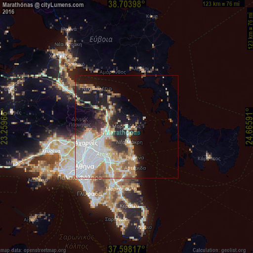
Analysis of Marathónas night lights 2016
Square area 10x10 km:
 0%
0%90-99
10.2%80-89
4.76%70-79
2.72%60-69
4.08%50-59
2.89%40-49
3.57%30-39
5.1%20-29
25.17%10-19
36.9%0-9
4.59%Square area 50x50 km:
8.83%90-99
6.01%80-89
2.79%70-79
3.75%60-69
4.5%50-59
2.53%40-49
2.18%30-39
3.01%20-29
5.69%10-19
10.06%0-9
50.64%Clear (daylight) street map image can be seen on geolist.org.
Map coordinates:
38° 42' 14.3" North, 23° 15' 34.8" East
38° 9' 11.4" North, 23° 57' 46" East
37° 35' 53.4" North, 24° 39' 57.3" East
Some cities around Marathónas sort by population:
• Néa Mákri
7.4 km =4.6 mi,  170°
170°
• Ágios Stéfanos
9.4 km =5.8 mi,  265°
265°
• Néa Pentéli
13.7 km =8.5 mi,  221°
221°
• Drosiá
9.4 km =5.8 mi,  246°
246°
• Anoixi
9.4 km =5.8 mi,  255°
255°
• Ekáli
12.1 km =7.5 mi, 246°
• Diónysos
9.1 km =5.7 mi,  233°
233°
• Kryonéri
11.7 km =7.3 mi, 261°
257717 (p: 7,170)
Sources (retrieved 2019-11-25):
» Earth at Night: Flat Maps 2012, 2016