Diónysos night lights from space
Night Light of Diónysos (Attica) from space (Greece) Src. Average luminocity for 10x10km area is 58.6039% and for 50x50km: 40.3019%.
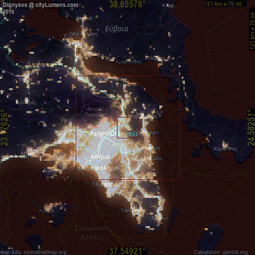
Analysis of Diónysos night lights 2016
Square area 10x10 km:
 8.93%
8.93%90-99
14.12%80-89
12.18%70-79
8.93%60-69
6.49%50-59
5.68%40-49
3.9%30-39
8.77%20-29
27.92%10-19
3.08%0-9
0%Square area 50x50 km:
11.87%90-99
9.14%80-89
4.07%70-79
5.29%60-69
5.38%50-59
3.71%40-49
3.56%30-39
3.91%20-29
7.14%10-19
11.07%0-9
34.86%Clear (daylight) street map image can be seen on geolist.org.
Map coordinates:
38° 39' 20.7" North, 23° 10' 34.5" East
38° 6' 16.5" North, 23° 52' 45.8" East
37° 32' 57.2" North, 24° 34' 57" East
Some cities around Diónysos sort by population:
• Kifisiá
6.9 km =4.3 mi,  240°
240°
• Néa Erythraía
5.2 km =3.2 mi,  255°
255°
• Ágios Stéfanos
5.1 km =3.2 mi,  336°
336°
• Néa Pentéli
5.2 km =3.2 mi,  199°
199°
• Drosiá
2.1 km =1.3 mi,  321°
321°
• Anoixi
3.6 km =2.2 mi,  329°
329°
• Ekáli
3.9 km =2.4 mi,  279°
279°
• Kryonéri
5.6 km =3.5 mi,  310°
310°
263064 (p: 5,651)
Sources (retrieved 2019-11-25):
» Earth at Night: Flat Maps 2012, 2016